
Aug 2023 Newsletter: Our Growing Fleet & Counting Trees: The Latest News from EAP
- Extreme Aerial

- Aug 1, 2023
- 3 min read
Updated: Sep 10, 2023

Lots new here over at Extreme Aerial Productions!
Our Growing Fleet
Since we’re serious geeks and always want to work with the very best technology available, we’ve purchased quite a bit of new equipment this year.
Two of our favorite new acquisitions are the SIRAS, which has amazing thermal by FLIR, and the Hovermap, which has amazing applications for creating SLAM-based LiDAR maps.
To see our entire arsenal of techy toys, check out our newly updated Drones & Equipment page.
Counting Trees Project
These days, we’re busy counting trees - yes trees - in 83 acres of forest in nearby Flagstaff. We’re using the power of advanced drone technology to scan the forest and provide accurate data about the trees.
Here’s a sampling of the kind of information we’re providing for our client:
Total number of trees on site: 2574
Elevation of trees
Identifying the precise center of each individual tree, plus trunk width and canopy width
Creating a digital surface with all trees wider than 6 inches (1135) removed so that a space plan can be dropped into the digital model and an analysis of the proposed space plan and how it will affect the remaining trees can be computed.
Within that surface, showing the grade from canopy to trunk so when excavation occurs, they know how to return the grade back to the original. (This is important for protecting the trees’ root structure, which lies 6-10 inches below the surface.)
Phew! All that data is making my head burst! Let’s look at this in pictures… This video shows the point cloud visualization:
So how do we deliver all of this data?
We’ve used photogrammetry and our new SLAM LiDAR system. We’ve filmed on foot and using UTV mounts. Then, we’re presenting the data to the client in various exhibits, including CAD, PDF and visual imagery to help them identify which trees need to be removed and what the cost will be. Our data is also helping them evaluate which remaining trees may potentially be negatively impacted by the proposed building plan. Finally, we’ve created a georeferenced tree map for the entire area so that field teams who are walking the site can use an iPad to compare the data to what they see firsthand.
We know you’re dying to see the results…Stay tuned for our next newsletter where we’ll share images, video and more!
3D CAD at Work: Example from a road somewhere in Arizona
Here is a recent 3D model of road work we did to allow the striping to be replaced. Using our CAD deliverables, we created an edge of asphalt calculation, centerline markings, etc so the road crews could easily repaint, too. We have been very blessed this year and have flown, processed and delivered linework for over 200 miles across the state.
Who doesn’t like tilt-up videos?
Check out these 2! One is by Riggs and one by McCarthy. Watch these babies come UP! We love watching the 100,000+ pound panels being manhandled into place in these two videos below:
What about helicopters on job sites?
Tilt-up wasn’t badass enough for you? Check out this cool video for Pueblo Mechanical. If you need a fast and precise HVAC pick - call Pueblo for any MEP need.
Sometimes it IS all fun and games
We had almost as much fun as the kids this July 4th! Here’s a video we filmed for the City of Scottsdale at the Stillman Railroad Park. We hope everyone’s Independence Day was as fun-filled as this one:
Mom, we’re on TV again!
Seen the latest Progressive commercial? Guess who filmed it… We loved shooting that bike cruising across the Tempe Town Lake Bridge.
How many miles have we flown?
Here’s an update! There’s no rest for the weary here at EAP! We’ve flown a whopping:
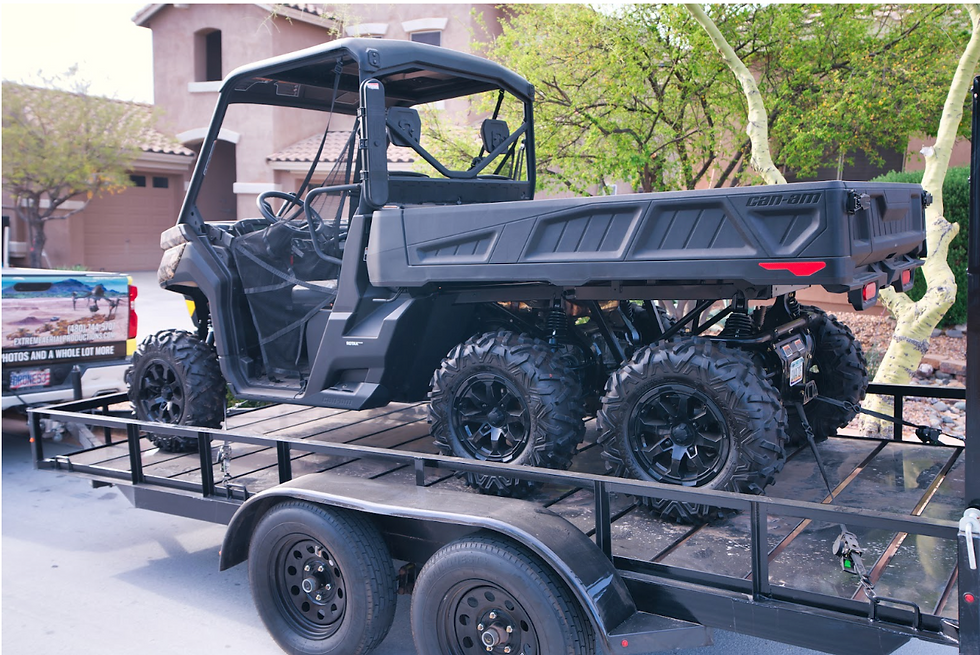
Wanna go for a ride in our UTV?
Did you know? Extreme Aerial rents out our Can-Am UTV!


Comments