
Why “Trust Me” Doesn’t Work Anymore
- Extreme Aerial

- May 14
- 4 min read
For a long time, project documentation lived in fragments.
A few jobsite photos. A couple of emails. Someone’s memory of what the roof looked like before the storm damage. Notes from a walkthrough that may or may not still exist six months later.
That worked well enough until projects became more expensive, timelines tighter, and disputes more expensive to untangle.
Now everybody wants proof.
At Extreme Aerial Productions, we’ve watched that expectation shift happen quietly across construction, inspections, surveying, insurance, and property management. The drone industry didn’t suddenly reinvent itself. Businesses became less comfortable operating without reliable drone project documentation and a verifiable record of what actually happened on-site.

The Paper Trail Went Airborne
Most projects today involve more stakeholders than they used to.
Owners are remote. Insurance carriers want documentation. Municipalities expect cleaner records. Contractors are expected to validate progress. Timelines move fast enough that disputes can surface before people even realize there’s a disagreement.
That creates pressure for consistent documentation.
Not polished marketing footage. Actual records.
Drone inspection services increasingly function as part of broader verification workflows across construction, roofing, infrastructure, and property management. Aerial data collection fills that gap because it captures site conditions in a repeatable way.
The same location can be documented over time using consistent flight paths, timestamps, and measurable imagery. Suddenly, questions that once relied on memory start relying on records instead.
Questions like:
Was the material already delivered?
Did site conditions delay the work?
Was that damage pre-existing?
Did the grading change after rainfall?
Was the repair actually completed?
Those are no longer casual conversations. They are operational questions with financial consequences attached to them.
Visibility Isn’t the Same Thing as Verification
This is where many companies misunderstand commercial drone services.
Good visuals are useful. Nobody’s arguing otherwise. But usable aerial deliverables matter far more when the information needs to support decisions later.
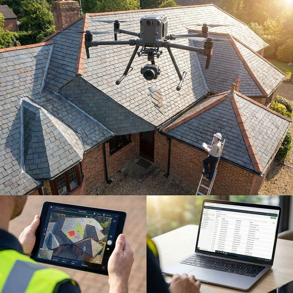
A drone roof inspection, for example, has value because it captures site conditions at a specific moment in time. In confined, interior, or difficult-to-access environments, specialized workflows such as FPV aerial inspection services can document conditions traditional inspection methods may struggle to capture efficiently. When done properly, that information becomes part of the project history.
That’s very different from simply taking aerial photos.
The same applies to construction progress documentation. Weekly flights are no longer just “nice updates” for stakeholders. Increasingly, they function as a running historical archive of site activity, sequencing, material staging, and visible progress.
Reality capture workflows are increasingly becoming part of standard project oversight because they create reviewable site history teams can reference long after work is completed.
Projects now generate a record whether teams intentionally manage it or not.
The companies adapting fastest are the ones treating documentation as part of the job, not an afterthought.
Accountability Changed the Workflow
One of the biggest shifts in recent years is how aerial documentation is being used after the flight.
Insurance carriers review it. Project managers reference it during disputes. Engineers compare conditions over time. Property owners use it to validate contractor work. Legal teams sometimes request it months after a project wraps.
That changes how drone inspection services are approached operationally.
Consistency matters more than cinematic shots. Repeatability matters more than dramatic angles. Reliable geospatial data matters more than flashy edits.
Frankly, some of the most valuable drone work today looks fairly boring to the average person.
Straight-down orthomosaic captures. Structured site progress flights. Repeat inspection paths. Controlled overlap. Clean metadata.
Not the sort of thing ending up in a sizzle reel.
But when someone needs to verify what happened on a site three months earlier, boring suddenly becomes extremely useful.
The Industry Quietly Changed Its Expectations
There wasn’t one dramatic turning point where companies collectively decided aerial verification mattered.
The shift happened gradually.
Projects became more scrutinized. Insurance claims became more detailed. Remote collaboration became normal. Documentation expectations increased. Stakeholders wanted faster answers with fewer gray areas.
The conversation has shifted toward using drones to verify project conditions, timelines, and documented site activity rather than simply capture visuals from above.
Eventually, “trust me” stopped being sufficient documentation.
That pressure created demand for reality capture workflows that produce consistent, defensible records without slowing projects down.
And that’s where drones became operational tools instead of novelty technology.
The interesting part is that many industries no longer treat aerial documentation as innovative. They treat the absence of documented aerial data as the risk.
That’s a very different mindset.
The Record Matters More Than the Flight
The drone itself still gets most of the attention. It’s the visible part. The bit everyone notices standing on-site.
But the real value usually shows up later.
When someone needs to verify conditions.When a timeline gets questioned.When a dispute surfaces.When a project team needs to look backward instead of forward.
That’s where structured aerial documentation earns its place.
Better Documentation Starts With Better Pilots
As aerial documentation standards continue to rise, the quality of the pilot behind the controls matters just as much as the equipment being flown. Consistent capture, repeatable workflows, airspace awareness, and usable deliverables all depend on proper training and operational discipline.
That’s one reason Extreme Aerial Productions also offers drone pilot training designed around real-world commercial operations, not just passing a test.
If your projects depend on documentation that can hold up under scrutiny, it’s worth working with a team that understands how documentation standards are changing across the industry.
Contact our drone team to discuss drone inspection services, aerial data collection, and documentation workflows built for real-world accountability.


Been testing Revolut as a payment method for a while, and the setup is fairly standard, download the app, register, verify identity with ID and address, and after that the card behaves like any regular one for online transactions. Processing tends to be fast, often under a minute, and same day withdrawals back to the app do happen in practice, though it depends more on the platform than on Revolut itself. Useful reference material can be cross checked at https://casinorevolut.no if you want to compare user experiences before drawing conclusions. Currency settings inside the app are worth adjusting in advance to avoid unnecessary conversion costs, especially on weekends when markups apply. Nothing extraordinary, just a functional fintech tool. Approach any financial…